Our top 10 maps: from Arctic voyages to around-the-world adventures
Written by Sam Knight, photographer & designer at Responsible Travel
I’ve long held a fascination with maps. I had a particularly inspiring geography teacher growing up and his passion for the world, combined with my parents’ love of OS maps for walking, led to the accumulation of stacks of maps for places I'd never been, and would probably never visit, many decades out of date, all piling up in the corners of my bookshelves.
As graphic designer and content editor at Responsible Travel I have the lovely task of creating the various maps for our travel guides and articles, the challenge of which is always how to clearly illustrate and label enough of the relevant information without getting lost in a spaghetti of routes, place names and icons. As such, they’re great fun to create and work on, often requiring their own nuance for each map. These are some of my favourites from our articles and guides. They are often of places I’ve dreamed about since childhood, but some I enjoyed purely because I had no idea where in the world they were, or how significant in size they were.
I’ve long held a fascination with maps. I had a particularly inspiring geography teacher growing up and his passion for the world, combined with my parents’ love of OS maps for walking, led to the accumulation of stacks of maps for places I'd never been, and would probably never visit, many decades out of date, all piling up in the corners of my bookshelves.
As graphic designer and content editor at Responsible Travel I have the lovely task of creating the various maps for our travel guides and articles, the challenge of which is always how to clearly illustrate and label enough of the relevant information without getting lost in a spaghetti of routes, place names and icons. As such, they’re great fun to create and work on, often requiring their own nuance for each map. These are some of my favourites from our articles and guides. They are often of places I’ve dreamed about since childhood, but some I enjoyed purely because I had no idea where in the world they were, or how significant in size they were.
1. Around the world by train
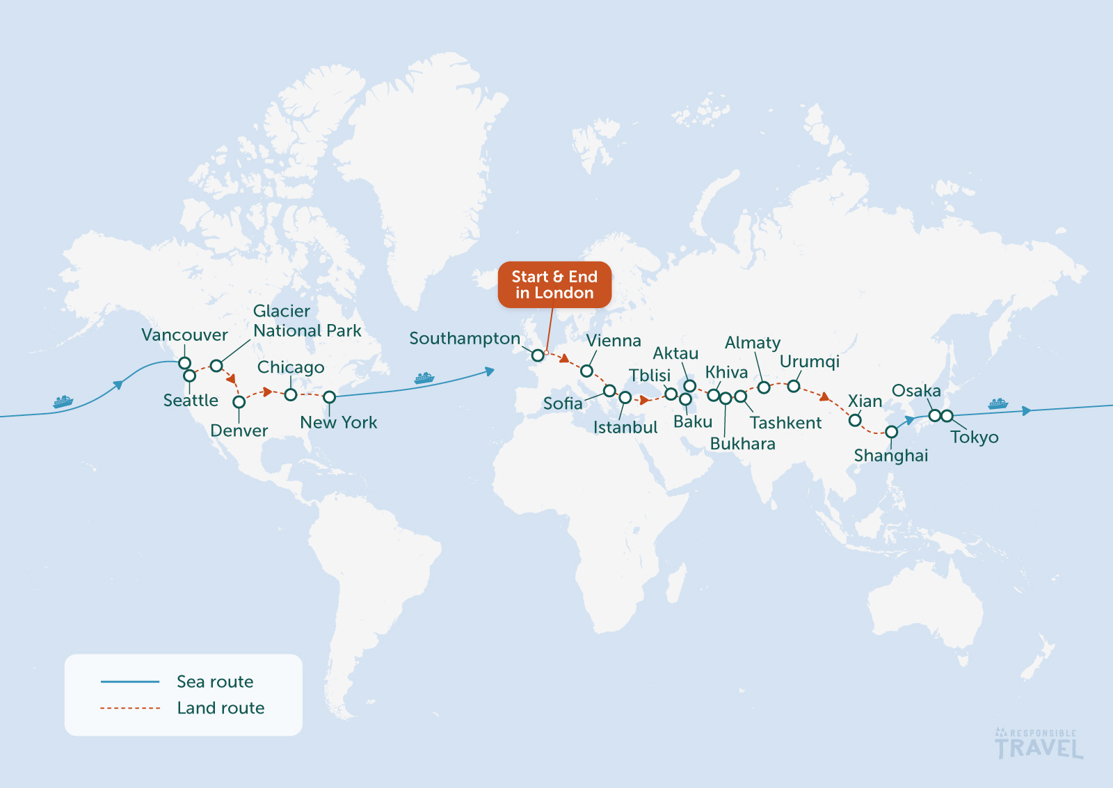
I can trace my strong sense of wanderlust back to my teenage years watching Charley Boorman and Ewan McGregor on TV, as they rode their motorbikes round the world from London to New York via deepest Siberia. The series was deeply influential to me and following their progress episode by episode as they wound a route across continents and through changing cultures and landscapes sparked my long-standing love of road trips and slow travel. Through them, I learned to appreciate the gradual shift of a journey rather than the sudden jolt a flight gives you as you step out of the airport and straight into another country’s customs, heritage, language and architecture.Clearly then, I’m a sucker for a round-the-world journey and this map for the around the world by train article on our Flight Free guide has it all as it crosses three continents, two oceans and many, many countries over the course of 14 weeks. The adventure is massive and leaves the imagination spiralling. A bucket list journey if ever there was one.
2. Sailing the Arctic Circle
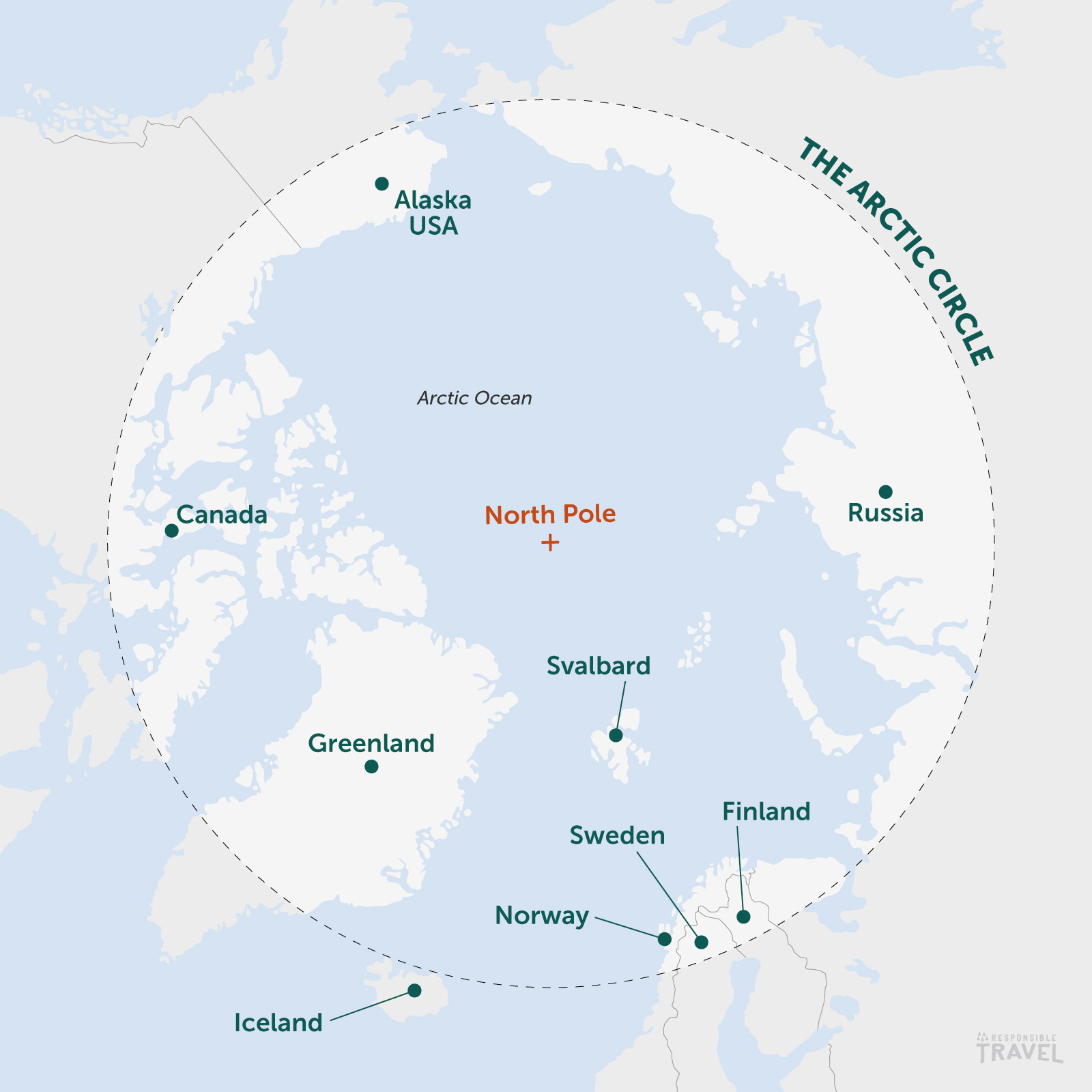
It’s not often we see the globe from above these days, mostly navigating via digital maps and seeing the world using the Spherical Mercator, a sphere-based projection that you’ll no doubt be familiar with from using Google Maps and other popular web-based map services. I can distinctly remember running my finger around the Arctic Circle on the well-worn globe in our geography classroom and daydreaming of Arctic voyages to the polar regions. The Arctic Circle has been the holy grail of adventurous travel for me, balancing true wilderness, hostile but incredibly beautiful environments and hardy skilled peoples whose subsistence is entirely entwined with the environment around them. It’s one of the places I really hope to visit one day, hopefully before the climate crisis has totally transformed the region, and I can’t think of a better way than a sailing trip.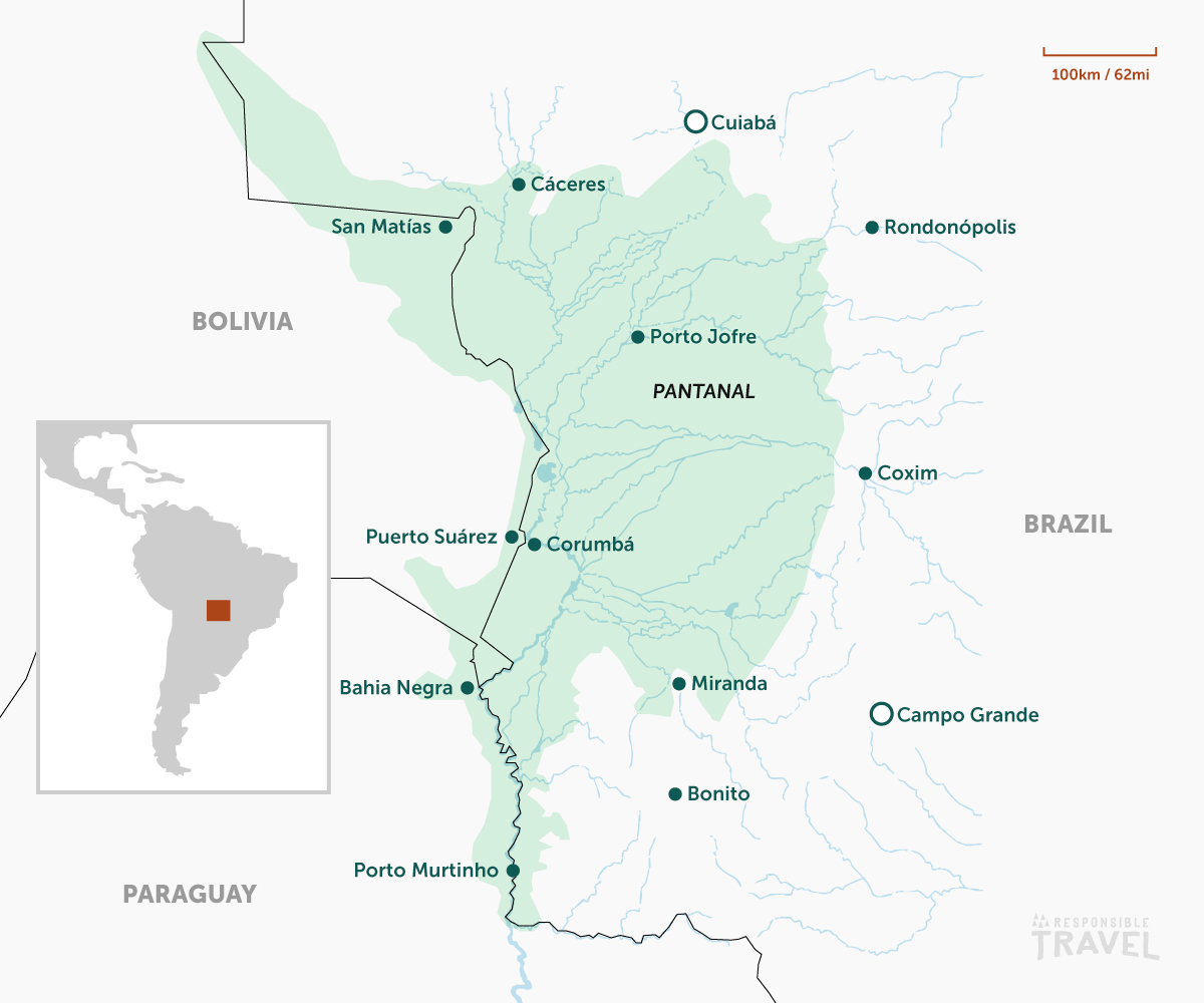
3. The Pantanal
I read a fair amount of nature and travel writing and also know a few photographers who have worked in the Pantanal over the years, so my rough knowledge of the species it houses, its size (roughly an enormous 150,000km2), the make-up of its environment and its importance for so many species were all known to me. When working on our Pantanal travel guide however I wasn’t all that sure of where exactly it was, simply knowing that it spanned some of Brazil, Bolivia and Paraguay. All huge countries in themselves, especially Brazil of which 80-85% of the Pantanal is located. Seeing it on the map really hammers home just how big this unique environment is and how I could begin to start planning a trip to the world's largest tropical wetland myself.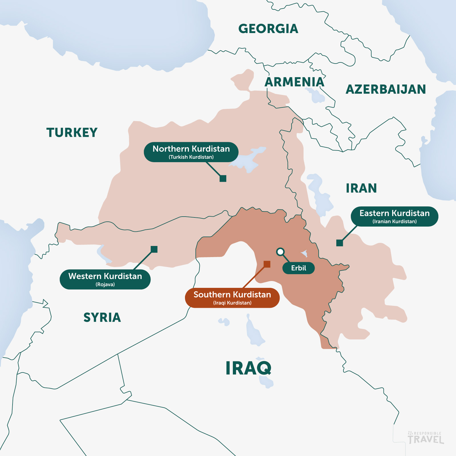
4. Kurdistan
Recently we published an article focusing on Iraqi Kurdistan, which was a fascinating and eye-opening read. Iraq has been on my radar for a while having been interested in the history of the region, but learning more about Kurdistan was even more fascinating, like did you know that “a 3,500-year-old clay tablet in the Slemani Museum contains a section of the world’s oldest epic poem, the Epic of Gilgamesh” or that “Erbil’s concentric-road layout centres around a raised mound that is one of the oldest settlements anywhere in the world”. Incredible! I also didn’t realise how large the Kurdistan region was as it sprawls across parts of Iran, Iraq, Syria and Turkey, even dipping a little into Armenia to the north-east. As will be a recurring theme with this top 10, I was fascinated by this newly acquired knowledge and just had to create a map showing Kurdistan’s range and its location within the wider region.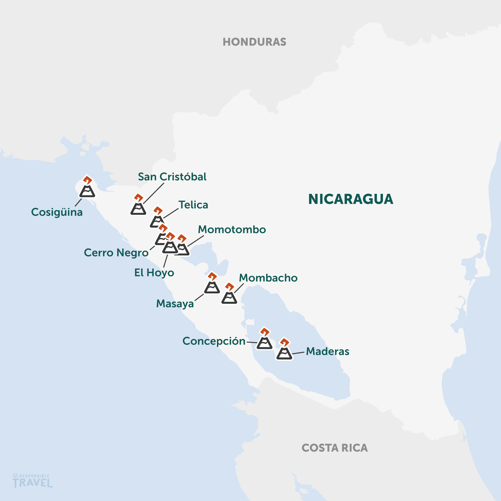
5. Nicaragua’s Volcanoes
Is there a better way to illustrate what goes on beneath the Earth's surface than a map of its volcanoes on the surface? Running down the west side of the country along the Pacific coast this band straddles the Cocos and Caribbean tectonic plates from north-west to south-east and is part of the Ring of Fire, which loops around much of the Pacific Ocean (and its plate of the same name). This is a hotspot for Nicaragua’s volcanic activity and it's always fascinating to see on a map as you can really get a sense of what is going on underneath the earth where those plates meet. It also perfectly illustrates why Nicaragua is known as the ‘Land of Lakes and Volcanoes’ as the volcanoes thrust up all along the west coast of the country. There are between 19 and 40 volcanoes in the country, but these are just the main ones we highlight in our article on the best volcanoes in Nicaragua.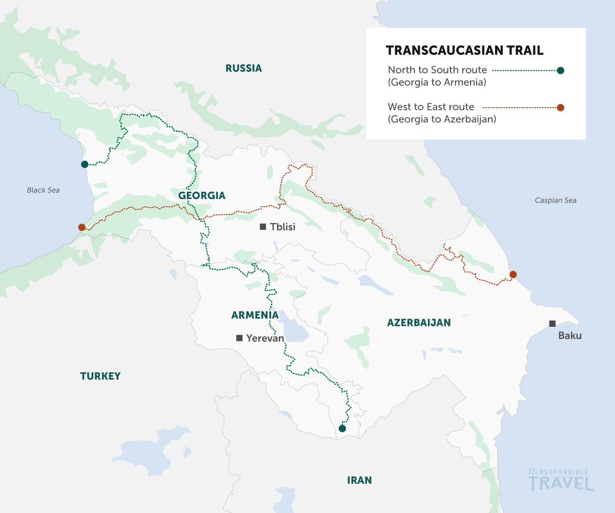
6. Transcaucasian Trail
Hands up, how many of you have heard of the Transcaucasian Trail? You’d be forgiven for not having heard of this one as it’s a relatively new long-distance hiking trail having been conceived in 2015, but it’s absolutely one to keep an eye on and if you’re interested in walking and the Caucasus, maybe start planning a trip now before it gets too popular! Time magazine even named it one of the 100 Greatest Places in 2019. The route is still under development with the long-term goal of creating two complete trails, the north to south route crossing Georgia from the Black Sea and Armenia to the Iranian border, and the west to east route running through Georgia from the Black Sea to the Caspian Sea on the west coast of Azerbaijan. The trail network connects miles of paths used for centuries by shepherds and local communities, giving you a wonderful connection to the land and its people in this fascinating and beautiful part of the world.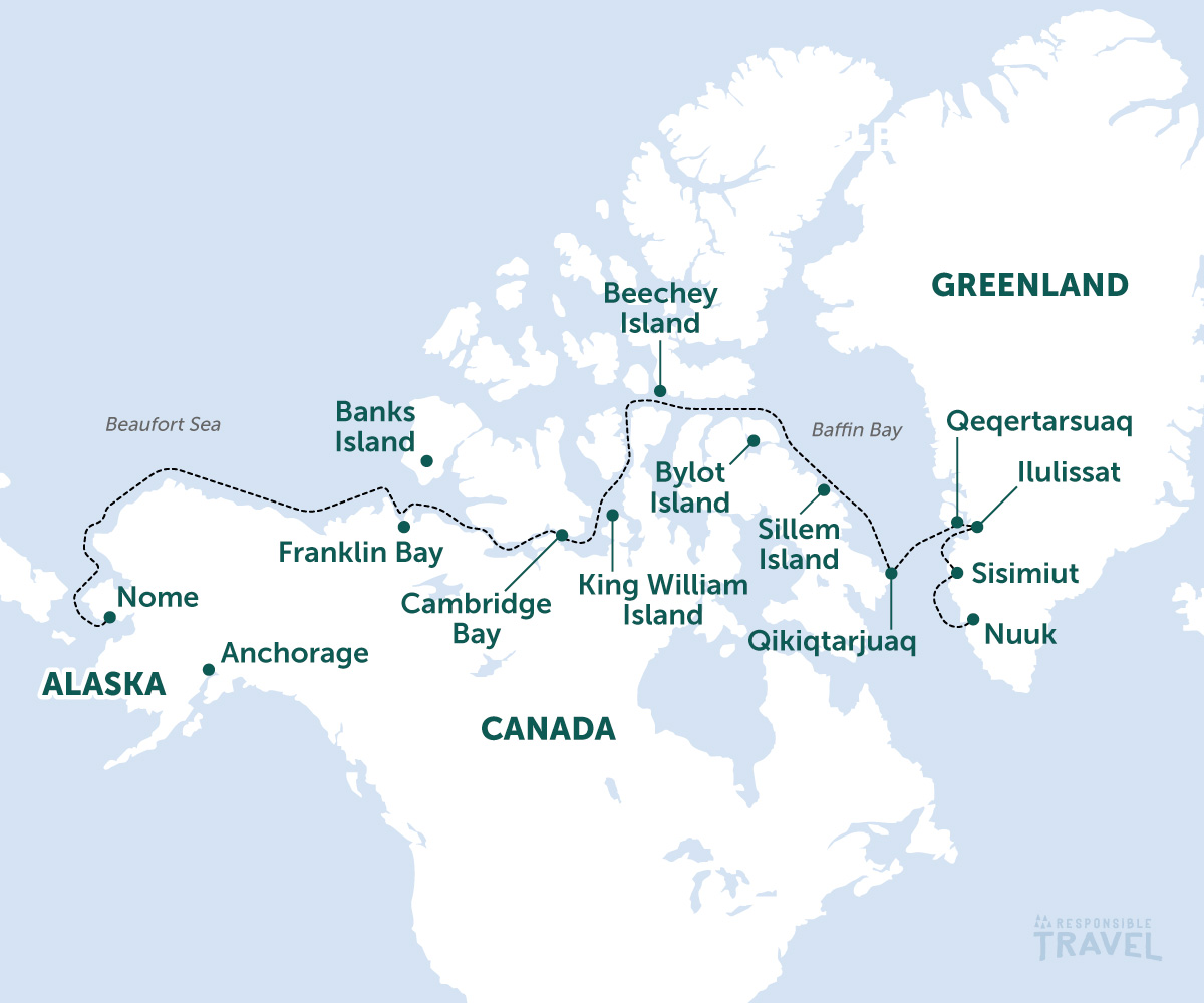
7. The Northwest Passage
Following in the footsteps of some of the greatest explorers in history, this map winds its way through icy northern waterways and around remote islands as it spans over 900 miles of historically ice-filled channels. It may be far more accessible these days due to the climate crisis than in the time of Roald Amundsen and Sir John Franklin, but it's no less adventurous and this map was fantastic to piece together from our trips because you journey from Nuuk in Greenland all the way to Nome in Alaska. My fascination with northern climes may bias me to this one, but this map feels like a true adventure and another trip of a lifetime.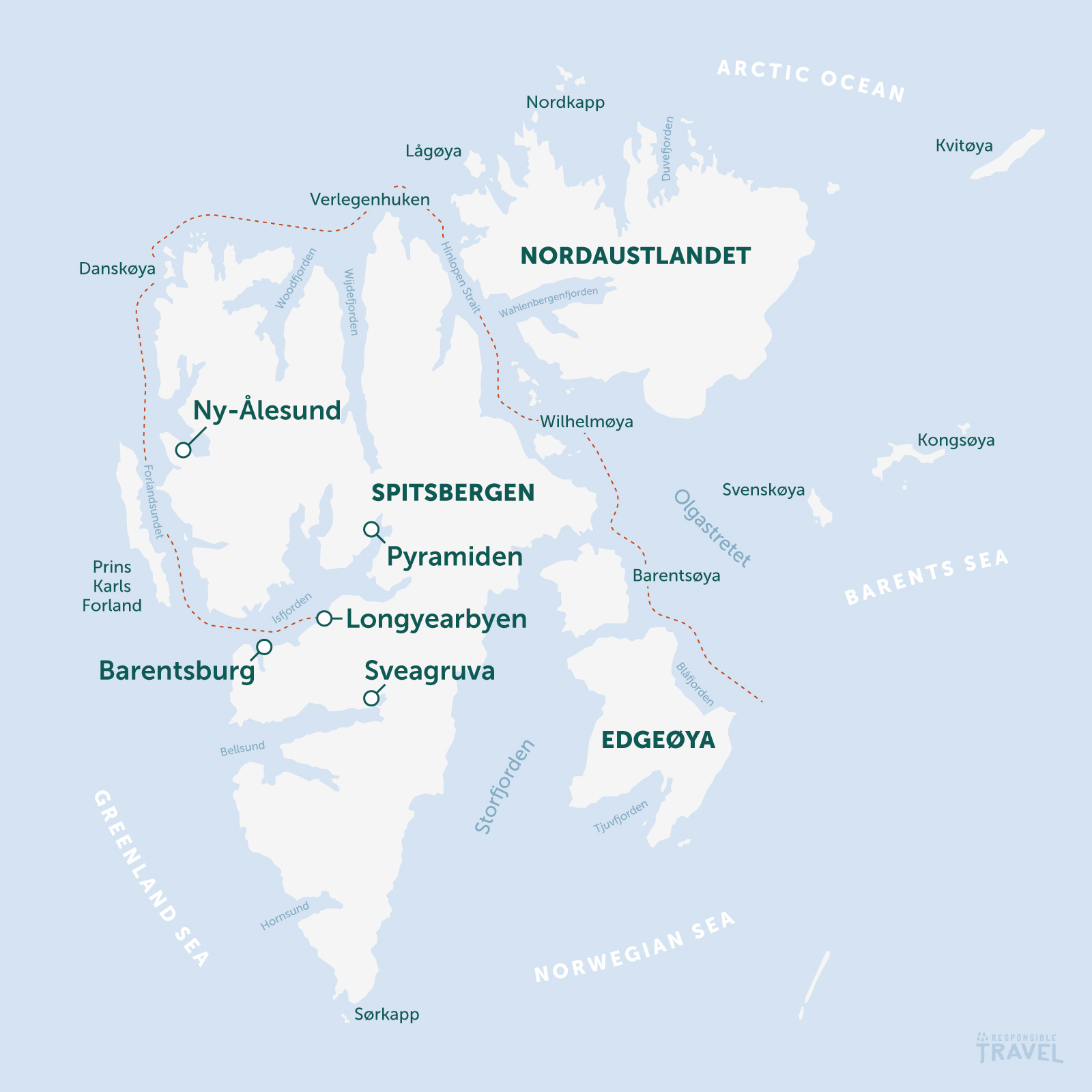
8. Spitsbergen Sailing
Halfway between Norway and the North Pole, Spitsbergen feels like the end of the Earth. With few people and hardly any roads, exploring this remote archipelago via boat can be a fantastic way to experience it and it can also be the best platform to see this epic, large-scale landscape. The network of fjords, inlets and peninsulas are an explorer’s paradise and putting together this map makes you realise just how interesting a sailing holiday around Spitsbergen can be. I outlined one potential route from Longyearbyen and around Spitsbergen here for this map, but with so much wilderness to explore, and so much history to find, Spitsbergen easily sails into one of my bucket list destinations.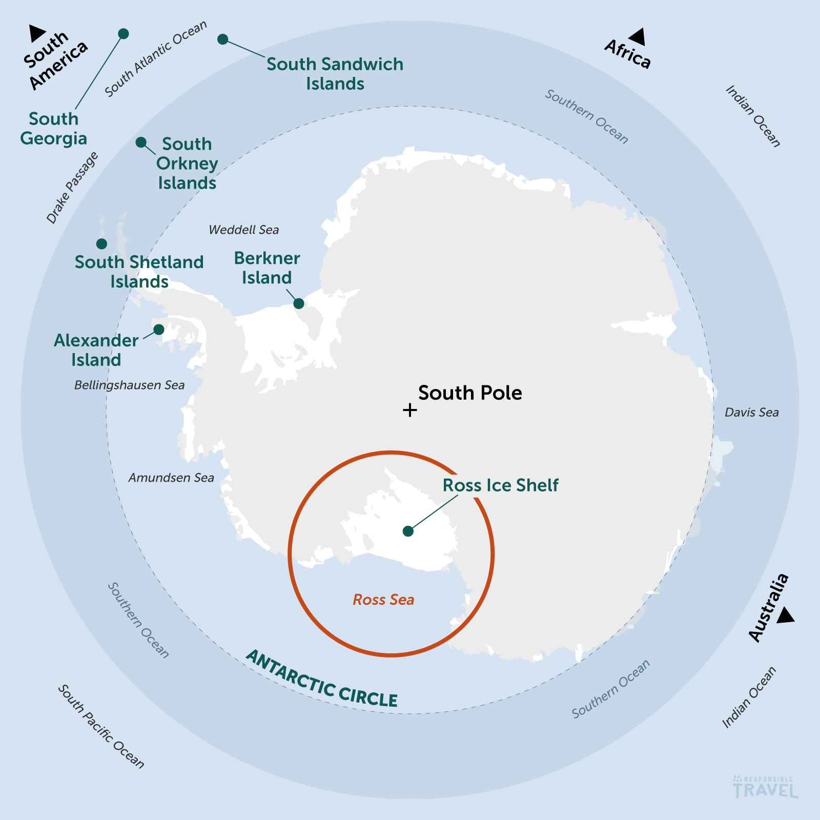
9. The Ross Sea / Antarctica
How often have you held a globe up and looked up at it from underneath? I’d wager very little. After working on the Arctic Circle map, it only felt right to flip the globe and see Antarctica from ‘beneath’ for our Ross Sea article so for this map I used the same projection. What’s immediately apparent with Antarctica though is that it is the continent rather than an ocean surrounded by continents. The Southern Ocean wraps around Antarctica and you’ll see the names of historic explorers, navigators and their ships who mapped these frigid waters appear in the names of the seas. There may be a recurring theme in this top 10: there’s always a sense of adventure or remoteness with my favourite maps as they take me places that are generally regarded for the most hardy of explorers.